Brading to Bembridge Circular: Via Windmill and Duver
- Daneen Cowling

- Aug 11, 2020
- 3 min read
This 8-mile walk is a great route to connect up the historic harbour and river towns along the Yar. It encompasses some Isle of Wight postcard views. Passing through several national trust and RSPB spaces, you're sure to encounter a wealth of wildlife and history along this walk.
The walk starts from Brading Train Station then on to Brading marshes via Lower Furlongs and across the train track. A path then leads you around the river, past rows of reeds and a blanket of lily pads. Once through the kissing-gate and over the bridge, follow the path round across another small bridge and into Centurions Copse.
For more walks in and around Brading Marshes, check out Brading Marshes to St Helens Duver, Brading Marshes to Gander Down or Brading Marsh Circular
Centurions Copse is a small strip of woodland before you get back onto open fields. It has a stream/sections of ponds running through it, lots of curious canopies and undergrowth, as well as pockets of marshland views. It is also said Centurions Copse is the spot of a historic doomed town of Wolverton which at the time, neighboured the Roman Port Town of Brading (Brading Haven - when sea levels were higher, which continued through to medieval times). The detailed legacy of Wolverton and Centurions Copse can be found here. Today, the Copse is an area of special wildlife interest, a favored habitat for red squirrels and rare birds.
Once out the Copse, it's pretty much a straight path through a few fields and past Bembridge Airport runway (a section of shorter grass..). Then the path leads you along the other edge of the marsh, which gives a different view and exposure of more interesting areas of the nature reserve. This continues into a field with a fair incline. this field frequently has cattle in so be sure to keep your dog on a lead here.
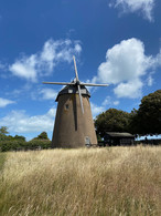
Just a short walk on you can then enjoy Bembridge Windmill, a national trust site that you can (for a price) enter. There's also a little ice cream stand, and some interesting history boards. From here, follow the path to your left, along the road for a short while before being able to enjoy a walk along Bembridge beach and follow it round to St Helens. Alternatively, you can cut through town if you fancy looking in some of the independent shops and reputable bakeries and cafes. Both routes then rejoin for a roadside walk through Bembridge Harbour. The road here is unfavourable but the views just about make up for it! And if they don't, having a nosey at all the wonderful houseboats does!
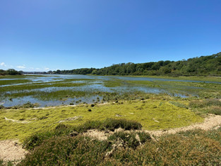
At the end of the Harbour and row of houseboats, turn on to Latimer Road and then onto the Quay, where you cross a small wooden bridge and get to enjoy some very picturesque views. Then - the best part of this walk - a walk along The Causeway Rock wall that runs through Bembridge Harbour over the outlet of the Yar at the Duver. At any tide state, this is brilliant to experience usually with clear waters you can see the flowing grasses below, which become exposed at low tide. Sometimes you can even spot some fish and other marine life going about their day. This wall takes you on to the Duvers Dune Landscape - another National Trust site full of ecological importance and deep history. From the wall, follow the path around the edge of the river and over a small wooden bridge, up the wooded path into St Helens.
All that remains is a walk from St Helens back to Brading - a fairly short walk past the several greens in St Helens, down the hill along Carpenters Road, then taking the path on the left at the bottom that runs beside the marshland. Once past a couple of houses and warehouses, the path permits wide-sweeping views across the wetland and out over to Culver Down. The path goes for about a mile, with amazing views either side and dense areas of trees, as well as a hidden pond. The path then leads onto the end of Quay lane, with a gate to the marsh on the left. You can either follow the marsh round again or walk the path that sits just behind and above the marsh, following the train tracks. Unsurprisingly, this takes you back to the gate you entered after crossing the tracks, which will then take you back to the station.
Overall, this walk is a great little circular, packed full of different terrains, river and sea landscapes, ample history and ecological richness.


Comments